- EQUATOR
- LATITUDE
- LONGITUDE
- TEMPERATE ZONES
- FRIGID ZONE
- LONGITUDE AND TIME
- STANDARD TIME ZONE
- INTERNATIONAL DATE LINE
UNIT 2 – EARTH – PART 2
EQUATOR
Imaginary line running on the globe divides it into two equal parts. This line is known as the equator. The northern half of the earth is known as the Northern Hemisphere and the southern half is known as the Southern Hemisphere.
The equator represents the zero degrees latitude.
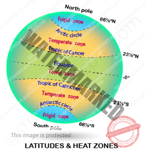
Tropic of Cancer (23½° N) – the Northern Hemisphere.
Tropic of Capricorn (23½° S) – the Southern Hemisphere.
Arctic Circle at 66½° north of the equator.
Antarctic Circle at 66½° south of the equator.
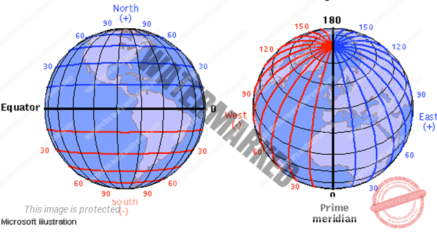
LATITUDE
Latitude is an angular distance measure north-south of the equator.
Latitude varies from 0 to 90° north and south.
All parallels north of the equator are called ‘north latitudes.’
Similarly, all parallels south of the equator are called’ south latitudes’.
Parallel is a line connecting all points of same latitude. All lines of latitudes are parallel to each other. Parallels of latitudes are shorter towards poles from equator.
LATITUDE & LONGITUDE
Great Circle: –
A great circle is the largest circle that can be draw to a sphere and it represents the circumference of that sphere.
Any plane that is passed through the centre of the sphere which bisects the sphere and creates a great circle where it intersects the sphere.
Arc of the great circle joining any two points on the earth surface is always the shortest route between the points.
Of all the parallels, equator alone makes a great circle. All other parallels are small circle.
Each meridian makes semi great circle
LONGITUDE
Longitude lines or meridians run between the North and South Poles. They measure east-west position.
The prime meridian is assigned the value of 0 degrees, and runs through Greenwich, England.
Where the British Royal Observatory is located. Longitude varies from 0 to 180° east or west.
Unlike lines of latitude, these lines are fairly equal in length. The degree of longitude decreases in length. For e.g. It is longest at equator =.67.17 miles =111km.
At 25° = 62.75 mile =101km
At 45° = 49 mile =80km
Origin Of This Spherical Coordinate System is at 0° latitude and longitude. It is found in the Atlantic Ocean just southwest of Africa. The two lines connect at 180 degrees or at the International Date Line. This helps to determining different time zones of the world.
TEMPERATE ZONES
The part of the earth’s surface lying between the tropic of Cancer and the Arctic Circle in the Northern Hemisphere or between the tropic of Capricorn and the Antarctic Circle in the Southern Hemisphere and characterized by having a climate that is warm in the summer, cold in the winter, and moderate in the spring and fall.
Here, mid-day sun never shines overhead on any latitude beyond the Tropic of Cancer and the Tropic of Capricorn. The angle of the sun’s rays goes on decreasing towards the poles.
It is the areas between the Tropic of Cancer and the Arctic Circle in the Northern Hemisphere and the areas between Tropic of Capricorn and the Antarctic Circle in the Southern Hemisphere
It has moderate temperatures.
FRIGID ZONE
Frigid zone-the area or region between the arctic circle and the north pole or between the Antarctic circle and the south poles frigid zone.
Areas lying between the Arctic Circle and the North Pole in the Northern Hemisphere and the Antarctic Circle and the South Pole in the Southern Hemisphere.
Areas are very cold. Because, the sun does not rise much above the horizon and rays are always slanting and provide less heat.
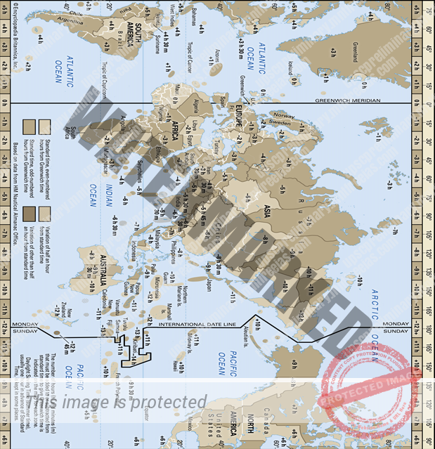
LONGITUDE AND TIME
The earth rotates 360° in about 24 hours; it means 15° an hour (or) 1° in four minutes.
When it is 12 noon at Greenwich, the time at 15° east of Greenwich will be 15 × 4 = 60 minutes, i.e., 1 hour ahead of Greenwich time, which means 1 p.m.
But at 15° west of Greenwich, the time will be behind Greenwich time by one hour, i.e., it will be 11.00 a.m.
Similarly, at 180°, it will be midnight when it is 12 noon at Greenwich.
STANDARD TIME ZONE
The uniform /common time used in the country/region is referred as standard time.
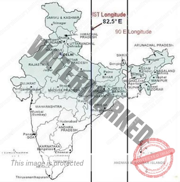
The countries which are very wide in territorial extent generally go for multiple time standard time zones. In India, 82.5°E is the official standard time zone.
There is a general understanding among the countries of the world to select the standard meridian in multiples of 7°30′ of longitude. That is why 82°30′ E has been selected as the ‘standard meridian’ of India. Indian Standard Time is ahead of Greenwich Mean Time by 5 hrs and 30 minutes.
There are some countries where there are more than one standard meridian due to their vast east-to-west extent. For example, the USA has seven time zones.
Time Zones of World
- Rus
- China
- Australia
- S.A
- Canada
- Africa
International Date Line (IDL)
It is an imaginary line agreed internationally which follows the meridian of 180° with some deviations to accommodate certain land areas.
Travelers crossing the date line from west to east gain a day and from east to west lose a day.
International Date Line passes through Bering Strait between Alaska and Russia.
IDL lies in the middle of the time zone. If it is crossed, there is no change in the clock but only the calendar.