- INDIA – PHYSICAL FEATURES
- THE HIMALAYAN MOUNTAINS
- REGIONAL DIVISIONS OF HIMALAYAS
- THE TRANS-HIMALAYAS
UNIT 3 – INDIAN PHYSIOGRAPHY – PART 1
INDIA – PHYSICAL FEATURES
- From a physiographical point of view, India can be divided into five regions.
- India is occupied by 29.3 per cent of area of Mountains and Hills.
- Plateaus Cover 27.7 % of Land Area.
- Plains Cover 43 % of Land Area.
The Five Physical Regions are.,
(1) The Himalayan Mountains
(2) The Northern Plains
(3) The Peninsular Plateau
(4) The Indian Desert
(5) The Coastal Plains
(6) The Islands
The Himalayan Mountains:
The Himalayan Mountains include the mountains and plateaus of northern Kashmir,
The hills of Arunachal Pradesh, Nagaland, Manipur, Mizoram, Tripura and Meghalaya.
The term “Himalaya” is derived from Sanskrit. It means “The Abode of Snow”.
The Pamir Knot, popularly known as the “Roof of the World”. The Pamir Mountains are a mountain range between Central Asia, South Asia, and East Asia, at the junction of the Himalayas with the Tian Shan, Karakoram, Kunlun, Hindu Kush, and Hindu Raj ranges. They are among the world’s highest mountains.
The Pamir Mountains lie mostly in the Gorno-Badakhshan Province of Tajikistan. To the North, The Tian Shan mountains along the Alay Valley of Kyrgyzstan to the south, They border the Hindu Kush mountains along Afghanistan‘s Wakhan Corridor to the East. They extend to the range that includes China‘s Kongur Tagh, in the “Eastern Pamirs”, separated by the Yarkand valley from the Kunlun Mountains.
The Himalayan Mountain are divided into three groups …
- The Himalayas
- The Trans-Himalayas
- Purvanchal or the hills of the North-East.
- The Himalayas:
- This is the highest mountain range of the world.
- It extends for a distance of about 2500 km from Jammu and Kashmir west to Brahmaputra gorge in Arunachal Pradesh east along the northern boundary of India.
- The breadth of the Himalayas ranges between 400 km in the west to 150 km in the east.
- The high peaks of this part such as Nanga Parbat, Nanda Devi and Badrinath are very far from the plains.
Three parallel ranges can be identified in the Himalayas. These are
(A) THE HIMADRI,
(B) THE HIMACHAL AND
(C)THE SIWALIK
- The Himadri (The Greater Himalayas)
- It is the northern most and the highest range of the Himalayas.
- The only range of the Himalaya which maintains its continuity from west to east.
- The average height of this range from sea level is about 6100 meters.
- The extent of this range is between the Nanga Parbat peak (8126 m.) in the west and NamchaBarva peak (7756 m.) in the east.
- The Greater Himalayas receive lesser rainfall as compared to the Lesser Himalayas and the Siwaliks.
The highest peak of the world, Mount Everest, (8848 m) is situated in this range. Kanchenjunga, Makalu, Dhaulagiri, Annapurna are some of the notable peaks
Kanchenjunga is the highest peak of Himalayas in India.
It is region of permanent snow cover. So, it has many glaciers. Gangotri, Yamunothri and Siachen are some of the glaciers. After melting of snow and ice, their water falls in the rivers of northern India making them perennial throughout the year.
- THE LESSER HIMALAYAS OR THE HIMACHAL
It is the middle range of Himalayas.
Height of this range varies from 3, 700 to 4,500 m.
Its width varies up to 80 km.
PirPanjal, Dhauladhar and Mahabharat are the mountain ranges found in this part.
The major rocks of this range are slate, limestone and quartzite.
This region is subjected to extensive erosion due to heavy rainfall, deforestation and urbanization
Major hill stations of the Himalayas are located in this range. Shimla, Mussourie, Nainital, Almora, Ranikhet and Darjeeling are the familiar ones.
- THE SIWALIKS OR OUTER HIMALAYAS
The Siwaliks extend from Jammu and Kashmir to Assam.
The altitude varying between 900-1100 meters elevation of this range is 1300 m.
The width of Siwaliks varies from 10 km in the east to 50 km in the west.
It is the most discontinuous range.
The longitudinal valleys found between the Siwaliks and the Lesser Himalayas are called Duns in the west and Duars in the east. These are the ideal sites for the development of settlements in this region.
REGIONAL DIVISIONS OF HIMALAYAS
From west to East, Himalayas have been divided into six regions
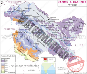
- Kashmir Himalayas,
- Himachal Himalayas,
- Kumaun Himalayas,
- Central & Sikkim Himalayas,
- Arunachal Himalayas
- Purvanchal Himalayas.
The Kashmir Himalayas (Located between the rivers of Indus and Sutlej)
The Kashmir Himalayas have the largest number of Glaciers in India.
The Ladakh region of the Kashmir Himalayas is India’s Cold Desert Biosphere reserve.
What is Cold Desert Biosphere?
Cold deserts have hot summers but extremely cold winters. These deserts are found in high, flat areas, called plateaus, or mountainous areas in temperate regions of the world and also in Tropical Country like India. Like other types of deserts, cold deserts get very little rain or snow.
A special feature of the valleys of Kashmir Himalayas is the Karewa deposits which are made up of silt, clay, and sand.
The Karewas are known for saffron cultivation and have orchards of fruits and dry fruits such as apple, peach, almond, and walnut.
The major characters of Kashmir Himalayas are Glaciers, snow peaks, deep valleys and High Mountain passes.
The important passes are
- Pir-Panjal,
- Banihal,
- Zoji-La,
- Saser-La,
- Chang-La,
- Jara-La etc.
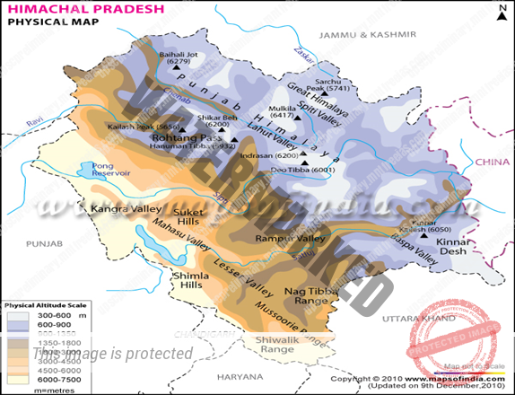
The Himachal Himalayas (Located between the rivers of Sutlej and Kali)
Himachal Himalayas are spread in Himachal Pradesh.
The Rohtang, Bara-Lacha, Shipki-La are important passes joining India and China.
The valleys of Kullu, Kangra, Manali, Lahaul, Spiti are known for orchards and tourist spots.
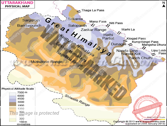
The Kumaun Himalayas / Central Himalayas / Garhwal Himalayas
Kumaun Himalayas are located between the Sutlej and Kali rivers.
They are home to India’s highest peak Nanda Devi.
Other peaks located in Kumaun Himalayas are Kamet, Trishul, Badrinath, Kedarnath, Dunagiri, Gangotri etc.
Gangotri and Pindar are important glaciers.
Gangotri Glacier is located in Uttarkashi District, Uttarakhand, India in a region bordering Tibet.
This glacier, one of the primary sources of the Ganges, is one of the largest in the Himalayas with an estimated volume of over 27 cubic kilometers.
The glacier is about 30 kilometers (19 miles) long and 2 to 4 km (1 to 2 mi) wide.
Around the glacier , the peaks of the Gangotri , include several peaks notable for extremely challenging climbing routes, such as ,Meru, and Bhagirathi III.
Chaukhamba, the highest peak of the group.
The terminus of the Gangotri Glacier is said to resemble a cow‘s mouth, and the place is called Gomukh or Gaumukh .
Gomukh, which is about 19 km (11.8 mi) from the town of Gangotri, is the precise source of the Bhagirathi river, an important tributary of the Ganges. Gomukh is situated near the base of Shivling; in between lies the Tapovan meadow.
The Gangotri glacier is a traditional Hindu pilgrimage site. Devout Hindus consider bathing in the icy waters near Gangotri town to be a holy ritual, and many made the trek to Gomukh, with a few continuing on to Tapovan.
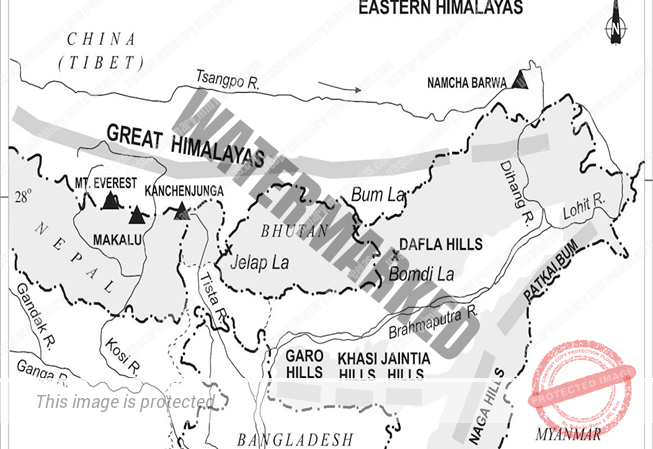
The Sikkim (Central) Himalayas (Located between the rivers of Kali and Testa)
- Sikkim Himalayas are located beyond the Kali River up to the Teesta River.
- Most of them are located in Nepal and known as Central Himalayas.
- These Himalayas are home to highest peaks of Himalayas such as Everest, Kanchenjunga, Makalu, Dhaulagiri, and Annapurna.
- It is characterized by very few passes. Two passes viz. Nathu La and Jelep-La are important as they connect India’s Sikkim to Tibet of China.
The Trans-Himalayas
It is also known as western Himalaya’s.
It lies to the north of the great Himalayan range.
It lies in Jammu and Kashmir and Tibetan plateau.
As its areal extent is more in Tibet, it is also known as Tibetan Himalayas. The Trans-Himalayas are about 40 km wide in its eastern and western extremities and about 225 km wide in its central part. They contain the Tethys sediments.
The rocks of this region contain fossils bearing marine sediments which are underlain by ‘Tertiary granite’ It has partly metamorphosed sediments and constitutes the core of the Himalayan axis.
The prominent ranges of Trans Himalayas are Zaskar, Ladakh, Kailash, and Karakoram.
iii. Eastern Himalayas &Purvanchal Hills (Located between rivers of Testa and Dihang.)
The Eastern Himalayas occupy the Arunachal Pradesh and Bhutan.
The important hills in this region are Aka Hills, Daphla Hills, Miri Hills, Mishmi Hills and NamchaBarwa.
The Dihang and Debang passes of Arunachal Pradesh are its parts. Passing from Arunachal Pradesh, there is an eastward extension of the Himalayas in the north-eastern region of India.
This is known as Purvanchal Hills. Purvanchal Hills comprises the Patkai hills, the Manipur hills, Bairal range, the Mizo hills, and the Naga Hills
These are low hills, inhabited by numerous tribal groups practicing Jhum cultivation
The physiography of Manipur is unique by the presence of a large lake known as ‘Loktak’ lake at the centre, surrounded by mountains from all sides.
Mizoram which is also known as the ‘Molassis basin’ which is made up of soft unconsolidated deposits. Most of the rivers in Nagaland form the tributary of the Brahmaputra.
While two rivers of Mizoram and Manipur are the tributaries of the Barak River, the rivers in the eastern part of Manipur are the tributaries of Chindwin, which in turn is a tributary of the Irrawaddy of Myanmar.
SUMMARY
Importance of Himalayas
- Himalayas blocks southwest monsoon winds and causes heavy rainfall to north India.
- It forms a natural barrier to the sub-continent.
- It is the source for many perennial rivers like Indus, Ganges, and Brahmaputra etc.
- Many hill stations and pilgrim centres like Amarnath, Kedarnath, Badrinath and Vaishnavi Devi temples are situated here.
- It provides raw material for many forest-based industries.
- It prevents the cold winds blowing from the central Asia and protects India from severe cold.
- Himalayas are renowned for the rich biodiversity.